Sub-Saharan Africa
Sub-Saharan Africa is that part of Africa that lies south of the Sahara Desert.
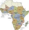
The Countries located in Sub-Saharan Africa are: Mauritania, Gambia, Guinea Bissau, Mali,Guinea, Sierra Leone, Liberia, Cote D'ivoire, Ghana, Burkina Faso, Togo, Benin, Niger, Nigeria, Cameroon, Chad, Central African Republic, Equatorial Guinea, Gabon, Democratic Republic of the Congo, Angola, Namibia, Botswana, South Africa, Madagascar, Mauritius, Comoros, Lesotho, Seychelles, Zimbabwe, Mozambique, Malawi, Tanzania, Uganda, Kenya, Ethiopia, Eritrea, Djibouti, Somalia, Sao Tome and Principe, Cape Verde, Zambia, Senegal, Burundi.
The first feature is Lake Victoria.
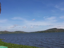
Lake Victoria is Africa's largest lake and is the largest tropical lake in the world. Lake Victoria is the second largest freshwater lake in the world. The size of Lake Victoria is said to be the size of Ireland. It supplies a good portion of the population water supply and has over 3,000 islands. This lake remarkably had dried up on three different occasions. This is thought to be from the ice ages. The fisheries on this lake are part of the economy bringing income and jobs. Ferries are used to transport people from the surrounding countries.
The next feature is the Horn of Africa.
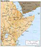
The Horn of Africa is mountainous and arid because of the closeness to the equator and the winds from the monsoons. The total rainfall for a average year is around 23 inches. The Horn of Africa is one of the areas in the world with the highest levels of malnutrition. Around 2 million people died within 10 years from war and famine from the drought and rising food prices. Coffee originated here in Ethiopia. Ethiopia is also produced many popular sports stars in running and football that have made it to the Olympics and won many gold medals.
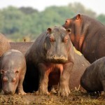
Now let's look at the Zambezi River
The Zambezi River is 1680 miles long and runs in north-west Zambia to the coast of Mozambique. It is has over cliffs, rapids,
swirls sulkily around drowned trees in Lake Kariba. Here you will find hippos in the Lower Zambezi. It empties into the
Indian Ocean. The Zambezi is also used for Hydroelectric power.
Indian Ocean. The Zambezi is also used for Hydroelectric power.
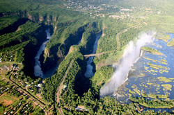
Moving right along we are going to look at Victoria Falls.
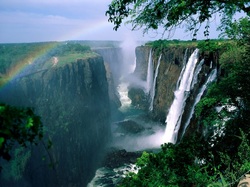
Victoria falls is 1708 meters wide and drops around 90 to 107 feet . There is around 550,000 cubic meters of water that falls over the edge every minute. During the months of February through May are flood seasons and September through January are the dry seasons. Activities that you can do when you visit the river are white water rafting, kayaking, canoeing, fishing and have guides take you on hikes and walks.
The last feature we will learn about is Mount Kilimanjaro.
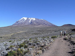
Mount Kilimanjaro runs in an east to west direction approximately 50 miles and is located in Tanzania. It is the tallest free-standing mountain rise in the world (encyclopedia). It is 15,100 feet and its highest peak at 1,940 feet called Uhuru. The slopes of receive more rain than the plains do with the southern slopes being the wettest. There are three volcanoes located in Mount Kilimanjaro: Mawensi, Kibo and Shira. The animals you will find here are buffalo, antelope, elephants, monkeys and many birds.
Climate:
Tropical wet/dry:Most of the region lies below the desert woodlands and Tropical Savanna or Steppe. This land lies between the Tropic of Cancer and the Tropic of Capricorn. These temperatures are above 64 degrees.
Tropical Wet: You will find this climate in the Congo Basin from the ITCZ. The Intertropical Convergence Zone follows around the equator creating rainfall in central and western Africa and winds from the north and the south come together. This convectional lifting causes all the precipitation.
Temperate Climates: These climates are scattered throughout the region mostly along the Southern tip of the continent.
Religion:
Most of the religion found in this region is Christianity which is in the Southern part of Africa and Islam in the Northern part. There are a few who practice African religions (animism) and some Hinduism also that are scattered throughout the region. Even though they practice one religion or another that does not stop those who still use witchcraft, evil spirits and practice as religious healers. The African religions (animism) believe in evil spirits, witches and spells for sickness and illness.
Transportation:
Transportation is hard here because of the high peaks and slopes. There are very few natural harbors for boats to travel. When in the desert camel caravans are used because of how hard it is to try to drive trucks and jeeps with lack of roads. The few roads that are located in the desert become covered in sand by the sand storms. Motorcycles are used in rural areas because of the little amount of fuel needed to drive them and little to non maintenance and up keep. Motorcycles and also be driven on gravel roads and in some areas of the desert. Buses are used because they can carry products and people. Bicycles are used mostly in the city and cars are only used where there are modern roads. Walking is the most used form of transportation.
Gender Roles:
In the economic factor of agriculture for income men and women both play a part with women working more then the men and making wages more below the poverty line then the men. Besides working, women carry out the growing of crops, transporting water, household chores. Children play a part in these daily routines and the females loose education time from having to help.
Population:
The population has tripled in the past 10 years and is growing faster than the other regions. This is because of better education, nutrition, health care and housing. Even though the population is growing it is still distributed unevenly and sparse. Women are having fewer children but mortality rate is lowering. The men are now helping with the population problems lowering family size, getting more education and abstaining from sex. HIV is the largest killer in Africa of infectious diseases and then TB and malaria. Life expectancy in this region is around the 40's.
Resources:
The resources found here are 27% of the world's gold and 50% of platinum. In western Africa oil and cacao beans are the main export. Eastern Africa supplies dried coconut, palm oil and soybeans. Then in central Africa tropical hardwoods are the main source of natural resource.
Agriculture:
In Sub-Saharan Africa, 66% of the people raise their own live stock and produce their own crops. They also hunt and fish. They sell some of their crops to pay their taxes. They export 80% of the coffee from Ethiopia, 50% bananas and livestock in Somalia. Most of the farms have anywhere from 2-10 acres to farm. The herders use their money they make from selling their cattle to pay for the crops that they need to eat. The farms are how the women make most of their money.
Environmental Issues:
Desertification- The dry aridity is increasing and moving to the south of the region. This is taking over most of the moist land that it encumbers. It turns them from moist nutrient soil to dry arid land and the vegetation for animals and forests are no good. This dry soil makes it hard for the water to be used for vegetation and animal life because it evaporates. Over the years the forest having been shrinking from logging, cultivation and weather. The forests are becoming non existent and some of the National Parks animals are close to extinction because of this.
Water- The water in this region is so scarce that there is not enough availability per capita. The small amount of water that there is being rerouted to satisfy industrial, agricultural and urban uses. The lands that had water now lack the use of it and it is not flowing where it was before. Contamination is another threat to the water because of pollution, human waste and chemicals that make it unsafe to drink.
Country of Focus:
South Africa is roughly twice the size of Texas (Pulsipher 2008). It is one of the top 10 emerging markets and accounts for 1/3 of Sub-Saharan production (Pulsipher 2008). You will find the riches natural resources and has world class stock markets and supplies goods to the surrounding countries. It is competitive in communication, energy, transport and supplies jobs to southern Africa (Pulsipher 2008). Tourism is increasing because of the beaches, mountains and prize winning vineyards. Tourism alone will increase 450,000 jobs (Circa, Ltd 2011)
Cuisine:
Because of the region is very diverse it has a variety of foods that are eaten. Some of the foods in the western part of the region are starchy root vegetables like yams, coco yams and cassava. The foods are cooked using flavorful spices and the use of shea butter and palm oil. Some of the beverages drank are palm wines and beer. In the eastern part of the region they eat cattle, sheep and goats which are now being viewed as currency and wealth. Spices are also used here some of which are curry, cloves, cinnamon, pomegranite juices, etc. Pork and non fish seafood is avoided by Christians and Muslims and no dairy and meat during lent.
References:
Cambridge International Reference on Current Affairs (2011). Country of Focus: South Africa. Retrieved from http://www.circaworld.com/blog/2010
Exploring Africa (no copyright). Teachers: Why Study Africa. Retrieved from http://exploringafrica.matrix.msu.edu
How Stuff Works, Inc. (1998-2011). Culture: Lake Victoria. Retrieved from http://geography.howstuffworks.com
New World Encyclopedia (2008). Organizing Knowledge for Happiness, Prosperity, and world peace: Sub-Saharan Africa. Retrieved fromhttp://www.newworldencyclopedia.org
The Pew Forum on Religion and Public Life (2010). Tolerance and Tension: Islam and Christianity in Sub-Saharan Africa. Retrieved from http://pewforum.org
Pulsipher, L. M., and Pulsipher, A. (2008). World Regional Geography: Global Patterns, local lives (4th ed.). New York: W. H. Freeman and Company, p. 364-367.
SA Places (no copyright). Southern Africa Places CC: Victoria Falls. Retrieved from http://www.places.co.za
Travel Guide to Africa (2009). Zambezi River. Retrieved from http://wingstoafrica.com
