South Asia is our next stop.
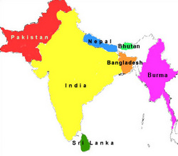
The countries that are in South Asia are: Afghanistan, Bhutan, India, Pakistan, Nepal, Bangladesh, Sri Lanka, Maldives
Now to look at some of the features in South Asia......
The Himalayan Mountains are the youngest and highest mountain peaks in the world. Located in India they are 1,500 feet long by 250 feet wide. They are divided into three categories: Great Himalayas, Middle Himalayas and Lower Himalayas.
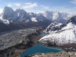
The Great Himalayas is where the highest peak is located and most of them are covered with snow. The Himalayan was once underneath the sea called Tethys Sea. Once the Indian Tectonic plate and Eurasian plate pressed together, this pushed up the Himalayan out of the sea forming the mountains. The raising of the mountains still continue today.
Ganges River is one of the longest rivers in the world. It flows through Bangladesh and India and empties into the
Bay of Bengal.
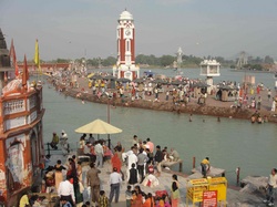
Because this river is the main life source of the region it serves many purposes. It is used for agriculture for farming and grazing, industries use it for energy and transportation.
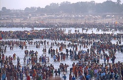
The river is very spiritual it is said "it cleans the soul" (Pilgrimage India 2009) and people come from miles to bathe in the river. Baptisms are also held here and cremation ashes are dumped into it too.
Next is the Thar Desert also called the Great Indian Desert is 77,000 square miles and is very hot and dry because of the mountain ranges and plains that surround it.
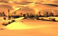
The Thar Desert absorbs all the rain that is in the clouds as they travel over the desert and therefore the rest of the region beyond the desert does not get the rain or moisture. The desert only receives around 4-20 inches of rain a year which varies. This desert is unique because the desert floor is always moving creating beautiful sand dunes which can reach up to 500 feet. This movement makes it impossible to settle because the sand continues to cover everything. The lakes in the desert and not drinkable because they are too salty only the vegetation and animals can consume it.
Now we will find some facts about Lake Wular in northern India.
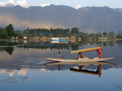
Wular Lake is the largest fresh water lake located in Asia. The lake can measure anywhere from 12 to 100 square miles. This lake does not have exact measurements because the size of the lake changes by season. This lake is very shallow with the deepest part you will find is 20 feet deep. About 60% of the fish caught are in Wular Lake and the people living along the lake grow water chestnuts because it has swampy shores. The lake is loosing its size because of all the farming that it is used for. The winds on the lake can cause devastation and has taken many lives. The deepest part of the lake is called "Gulf of Corpses" (Lake Lubbers 2007-2011). The market places here have apples, walnuts, woven blankets and carpets and are said to be attractive to visitors. The lake also has a bird sanctuary where you can find and variety of birds from different species of eagles, hawks, pigeons, wood peckers, orioles and so forth.
The last feature we will look at is the South Asian Rainforest. This rainforest is the oldest rainforests of them all.
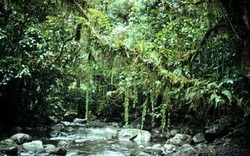
The temperatures in the rainforest range from 70 to 90 degrees with very high humidity. The reason for this is because of its closeness to the equator and from being surrounded by water. The dipterocarp trees that grow here in the rainforest can get as big as 120 feet and grow towards the sun. The dead trees and shrubs are consumed fast by the soil and plants and roots grow towards the surface to get these nutrients and can reach 30 feet high. The fruits that grow on these trees produce in intervals and not at the same time ranging from every 3 to 10 years so large amounts of fruit can't be produced. The rainforest has tropical-wet climate and relies on the two monsoon seasons. If it did not have this weather it could be devastating to the forest especially if it had to worry about fires.
Climate:
In April and May it is monsoon weather in Southern Asia. In the lowlands the heat is in the hundreds just in the shade, roads are covered by dirt and tornadoes kill. This is the time of the year that food must be purchased because growth is impossible. Summer time is June until end of October and this is the time of flooding. It rains so much that the rivers continuously over flow. During this time the flooding is so intense chickens are kept on the roofs of houses and boats with belongings in them need to be tied down to trees. When you go up into the highlands this is where you will find the cool part of the region. The higher up you go, the colder it gets.
Population:
South Asia is one of the most densely populated country in the world (Pulsipher 2008). Most of the population lives in the cities because of the jobs and better education opportunities. South Asia has some of the largest cities in the world: Mumbai, Kolkata, Delhi and Dhaka. Because of South Asia's rapid growth the population is already more than that of China. Now because of the growing population and the country not able to keep up with its needs to support the population they are starting to reduce birth rates. The young make up the majority of the population at 1/3 under the age of 15 (Pulsipher 2008).
Religion:
There is a variety of religious traditions practiced in South Asia. Some of these religions are: Hinduism, Buddhism, Sikhism, Jainism, Islam, and Christianity. Most of India practices Hinduism. The origin of Hinduism is in the Ganga Plain (Pulsipher 2008). During the religious festivals that they celebrate every 12 years people bathe in the Ganga and Yamuna rivers. A small percent of the population is Buddhism in southeast Asia. Sikhism is found mostly in Punjab and this religion is said to be of authority mainly as military and police. Jainism is in the western part of India and is practiced less than Buddhism. Jainism is high in education, vegetarianism and nonviolence ways. A small percentage of people practice Christianity in India, Sri Lanka and Bangladesh. Animism is practiced in central and northeastern India, some are incorporated in Hinduism, Islam, Buddhism or Christianity (Pulsipher 2008). The Islamic followers are found in Afghanistan, Pakistan, Bangladesh and Maldives.
Agriculture:
In South Asia 60% of the population is active in agriculture. The crops here are grown in what is called "double cropping" because of the climate. Crops are here are grown in the winter and then others grown in the summer. Rice is the main crop grown in South Asia and wheat is the second. The Cattle that are grazed in Pakistan and Afghanistan use irrigation systems because it is so dry. Drought from the monsoons was causing flooding and starvation because it was ruining the crops. Because of this damns were built to help contain the water and for hydroelectric power.
Environmental Issues:
Deforestation- is one of the environmental issues in South Asia. Clearing away the forests for agriculture, living and logging has been a huge part in deforestation. The tourist demands on the forest also from using the wood for cooking, heat and trails for the tourists to walk and climb. When the railroad system was built in too hurt the forest making slopes and eroding the land during the rain season.
Water Issues- When you look at the size of South Asia and know that 20% of the world population is there it is hard to believe that only 4% of it has fresh water (Pulsipher 2008). India and Bangladesh are constantly disputing the water system with India using it the most by directing the flow towards it and not leaving much for Bangladesh. This is ruining the fish farms, land and causing lack of water for the people. The purity of the water is also another problem. When the Hindu people die they come to the Ganga River to be cremated and have their asses put in the water. Then you have the industries and people who dump their sewage wastes into the water. The sewage systems built years ago have over gone their capacity and therefore the waste ends up in the water system.
Industrial Pollution- Industries have not only polluted the water they are also polluting the air. According to Pulsipher & Pulsipher (2008) "Emissions from vehicles and coalburning power plants are so bad that breathing Delhi's air is equivalent to smoking 20 cigarettes a day." From all this pollution it is causing acid rain which is destroying good land for farming.
Country of Focus:
The country of focus that I chose was Sri Lanka. Sri Lanka is an island located on the southeast coast of India. This beautiful island has a mountain massif almost 8,200 feet high. The weather here has monsoons that create luxurious forests and rivers that can be used for hydroelectric power. The land is used for cultivation and forest. The majority of the people here are Buddhists.
Transportation:
Transportation in South Asia is limited due to the lack of infrastructure and poor roads. With the high transport travel on these roads the maintenance is not kept up with to handle its needs. Big buses are used to haul people and goods. In the city where the population of people is so crowded that you will see bumper to bumper cars, bicycle rickshaws with drivers. People cling to the side of buses to hitch rides. Tuk-tuks are like an electric motorcycle or scooter used in the city to get inexpensive transportation. Taxi's are another form of transportation in the city. The rivers use boats for carrying out their products.
Resources:
The main natural resources found in South Asia are iron ore, bauxite, copper ore and high in reserve of coal. Along the rivers and coasts there are fisheries that use hydroelectric power to operate. The richest resource found is the forests in India. Then there is petroleum. India has many pipelines running through it that lead to the refineries. Some of the petroleum is transported by big tankers too.
And my favorite Cuisine:
Cuisine in South Asia is a variety of Indian Cuisine and Pakistani Cuisine and also a touch of Afghanistan. Afghanistan uses a mixture of the surrounding countries spices and dishes to prepare its food. They call it "cooking of three."( Many spices are used in cooking and the with rice being a main resource it is also a staple of the south. Left over foods are not common here, they make what they will consume that day. Bread that is fried on a griddle called "chapatis"is eaten with every meal. Fried vegetables,ab rice, curd, pickles and an all american favorite dessert "kheer" or as we call it rice pudding. The foods they eat are not greasy, they are steamed or roasted. Pakistani cuisine is that of the Islam religion. They are not allowed to eat pork or drink alcohol. The main dishes are made from beef, chicken, fish and vegetables. Here herbs, spices, almonds and raisins are used too. One dish that is a treat to them is "shahi turka" which is made with sliced bread with milk, cream, sugar and saffron.
Cuisine in South Asia is a variety of Indian Cuisine and Pakistani Cuisine and also a touch of Afghanistan. Afghanistan uses a mixture of the surrounding countries spices and dishes to prepare its food. They call it "cooking of three."( Many spices are used in cooking and the with rice being a main resource it is also a staple of the south. Left over foods are not common here, they make what they will consume that day. Bread that is fried on a griddle called "chapatis"is eaten with every meal. Fried vegetables,ab rice, curd, pickles and an all american favorite dessert "kheer" or as we call it rice pudding. The foods they eat are not greasy, they are steamed or roasted. Pakistani cuisine is that of the Islam religion. They are not allowed to eat pork or drink alcohol. The main dishes are made from beef, chicken, fish and vegetables. Here herbs, spices, almonds and raisins are used too. One dish that is a treat to them is "shahi turka" which is made with sliced bread with milk, cream, sugar and saffron.
References:
Afghanistan Journey to the land of Afghanistan (2009). Food in Afghanistan. Retrieved from
http://afghanistan.saarctourism.org/food.html
AsianInfo.org (2010). Food in India. Retrieved from http://www.asianinfo.org/asianinfo/india/food.htm
Blue Planet Biomes (last updated 09/23/2010). Southeast Asian Rainforest. Retrieved from
http://www.blueplanetbiomes.org
Food in every Country (2011). Pakistan. Retrieved from
http://www.foodbycountry.com/kazakhstan-to-South-Africa/Pakistan.html
Global taste (2008). Adventures in eating: Eating in Asia! Retrieved from http://www.globaltasteours.com
Karl Grobl Photojournalist (2002). Ganges River India. Retrieved from http://www.karlgrobl.com
Lakelubbers LLC (2007-2011). Lakes for Vacation and Recreation: Wular Lake, Jammu and Kashmir, India. Retrieved
from http://www.lakelubbers.comwular-lake-1583
Learning about Rainforests (no copyright). Where are the Rainforests. Retrieved from http://www.srl.caltech.edu
New World Encyclopedia (18 April 2008). Organizing Knowledge for Happiness, Prosperity, and world peace: Thar
Desert. Retrieved from http://www.newworldencyclopedia. org
Pilgrimage India (2009). Holy Rivers: Ganga/Ganges River. Retrieved from http://www.pilgrimage-india.com
Pulsipher, L. M., and Pulsipher, A. (2008). World Regional Geography: Global Patterns, local lives (4thed.). New York:
W. H. Freeman and Company
Traveling Tips Blue Sense (2010). Adventures to Himalayan Mountains. Retrieved from: http://skvots.net/adventures-himalayan-
mountains.html
Yahoo Images (no copyright). Thar Desert Pakistan India
