Next we are going to look at North American
and Southwest Asia
and Southwest Asia
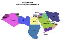
North Africa and Southwest Asia are known as the land of five seas. They are the worlds driest region in the world. The countries that make up the parts of this region are:
North Africa's countries are: Sudan, Egypt, Libya, Tunisia, Algeria and Morocco. The countries found in Southwest Asia are: Iran, Turkey, Syria, Iraq, Kuwait, Lebanon, United Arab Emirates, Oman, Yemen, Saudi Arabia, Jordan, Israel, Bahrain and Qatar.
North Africa's countries are: Sudan, Egypt, Libya, Tunisia, Algeria and Morocco. The countries found in Southwest Asia are: Iran, Turkey, Syria, Iraq, Kuwait, Lebanon, United Arab Emirates, Oman, Yemen, Saudi Arabia, Jordan, Israel, Bahrain and Qatar.
So we are going to look at the features found here starting with the Sahara Desert.
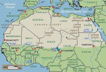
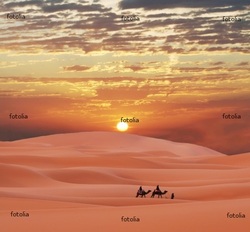
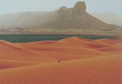
The Sahara Desert is the biggest desert in the world. From North to South it is from 800-1200 miles long and from East to West it is at least 3,000 miles long. The Sahara Desert is the hottest place on earth with temperatures at times getting as hot as 136 degrees. The average rainfall a year in the desert is less than 3 inches a year. The desert covers 1/3 of African continent around the size of the United States. It is bordered by the Atlantic Ocean on the West, the East side of the desert is bordered by the Red Sea and on the North by the Mediterranean Sea. The areas that the desert covers is part of Morocco, Western Sahara, Algeria, Tunisia, Libya, Egypt, Mauritania, Mali, Niger, Chad, Ethiopia, Eritrea and Somalia.
The only water you will find in the desert is from little oases that are scattered throughout the dessert. This is where you will find the majority of the population that lives in the desert. This is where the farmers graze their cattle and where travelers stop to stay when passing through. Without these oases people would not be able to cross the desert.
The next feature in this region is the Nile River.
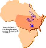
The Nile River is the longest river in the world at 4,184 miles long.
The river runs from Uganda to Ethiopia covering 9 countries: Ethiopia, Zaire, Kenya, Uganda, Tanzania, Rwanda, Burundi, Sudan and
Egypt.
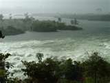
The spring flooding along the Nile river make the soil fertile.
Most of the drinking water and water for farming is produced from the
Nile river.
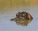
The Nile river is also the home of the crocodile that live
and nest along the river. People like to take river boat rides on the
river to explore and see what it has to offer.
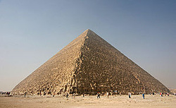
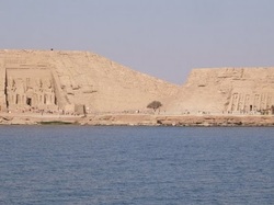
The next feature we will look at is the Great Pyramid of Giza
The Great Pyramid of Giza was built in Egypt on the Giza plateau in 2550 B.C. Pharaoh Khufu had his people build it for him and his wives. It is the biggest pyramid ever built out of stone blocks that go 481 feet high. This pyramid is a total of 2.3 miles high. It has three burial chambers in it The center of the pyramid is for Khufu's burial chamber, and then the one below was for the wives and the extra chamber was for his statue. His own chamber that he stayed in was 25 feet high and had traps everywhere to keep out thieves.
Moving right along we will explore the Zagros Mountains. These mountains are Iran and Iraq's largest mountain range.
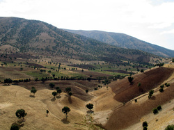
The length of the mountain range is 1500 km long and runs from western Iran to the southern part of the Persian Gulf at the Straits of Hormuz. This mountain range was formed from the collision of the Eurasian and Arabian tectonic plates. The highest point is Mt. Dena at 16,998 feet. The mountain traps petroleum which is the gulfs biggest production product. Some of the features you will find on these mountains are salt domes and glaciers which are important for oil exploration. The main oil fields are located central foothills of the mountain range where you will also find limestone rocks and fossils.

The last feature we will talk about is the most famous "Red Sea".

Of course we all know the Red Sea is a biblical landmark famous for its story about Moses and the splitting of the Red Sea. Even though we all know of the sea in the biblical way we will learn more about the facts that make up the sea instead.
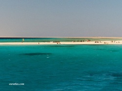
The Red Sea is 1,200 miles long running
from Suez, Egypt to the Straits of Mandeb. It separates North Africa and
Southwest Asia. This sea contains most of the worlds warmest sea
water. Of all the traveled water ways in the world, the Red Sea is by
far the heaviest traveled waterway.
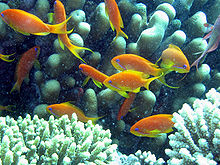
The Red Sea continues to widen every year. Scientist believe that eventually the Red Sea will become and ocean. If you have an opportunity to go and explore the Red Sea, you should for sure go scuba diving or snorkeling. There are tons of coal reefs to explore!
Resources: As we discussed earlier oil is a huge resource for this region. Oil industries and manufacturing is where most of the economical income comes from.
Religion: The different religions that are practiced here is mainly Islamic. You will find in Israel that the population is still practicing the bible culture and are Jewish. In Lebanon you will find them practicing Christianity.
Climate: As we learned earlier the Sahara Desert makes up 1/3rd of the continent so the climate here is arid and semiarid with a few small areas that are steppe. The areas with moisture are along the rivers and oceans where the Mediterranean is in the north.
Population: The population of this region is twice that of North America at an estimate of 450 million people. With the desert taking up the majority of this region most of the population lives along the rivers and seas. The many oases you will find throughout the desert is where the farmers live and where people who are traveling through the desert will stop and stay to get water and food. Without the oases no one would ever be able to travel from one side of the desert to the other.
Environmental Issues: Some of the environmental issues we will talk about are wastes, water and desertification.
Waste is out of control in Africa. There are no waste stations, landfills or dumps for the people to put their garbage. Everywhere you look in the streets, rivers and land, garbage is everywhere and it is a norm for the people that live here. It does not bother them to see it spread about and they have not tried to find a place to put it.
Water is a major issue for this region. With the desert and arid weather water is very scarce. People here learn many ways to conserve their water and make it last. There is a short supply and the areas where you find rivers, people are making damns to try to help holding water in populated areas. These damns create erosion, pollution and fish migration ceases. The poorer people in these areas suffer from the settlement of others to work the damns.
Desertification is one of the environmental problems in Southwest Asia with much of the population and manufacturing companies using wood for fuel and heat. The burning of the wood is causing pollution and clogging of the waterways. Between the deserts growing more and more every year and the construction companies plowing down forests they are loosing their soil.
Transportation for the people in these regions is mainly by boats and fairies on the rivers with the Nile River being the heaviest traveled river. On land, because of the desert animals are used and some trucks. In the populated areas where there are streets people use cars and taxis and trains. Airplanes are used for long distant travels and places where airplanes can land.
Country of Focus is Saudi Arabia. Saudi Arabia makes up about 80% of the Arabian Peninsula. Most of Saudi's land mast is made up of desert. This country is high in oil production. They use this money to pay for public debt, education, developmental projects and security for terrorists and they are paying the citizens more for their housing, health care and education.
Role of Genders: Because of the diverse cultures in this region the roles change and are different where the different religions are. This is especially changing in the cities where Western civilization is influencing the gender roles. In most the countries women perform 60-80% of the agriculture labor then the men. The men grow crops that they can use as cash crops and the women grow crops for family use. The men are looked at more of authority figures and tend to conduct their business with men. When it comes to education, literacy and jobs women are behind the men. Most jobs performed by the women are servants, traders and prostitutes. In some cultures the women are not allowed the leave the home. The Islam and Arab countries enforce the women to be subordinate to the men and some Muslims still have multiple wives. In the northern countries women are starting to be more active and participate in politics and political parties.
And the best part......Cuisine.
When we explore the different countries and religions the staples change from place to place in this region. One staple that is found throughout is flatbread, mutton, kebabs and the use of hot peppers, black peppers, cloves, strong spices and gnee - or butter oil. Rice and beans are used a lot too but the starches change. Africans use local fruits, cereals, grains, milk and meat products. They serve most their meals as Ugali, or starch with meat or stew. Starchy roots are served with their meat and the use of Tapioca for flour like substance. They make a peanut stew with chicken, okra, ginger and other spices. They occasionally eat meats like crocodile, monkey, antelope and warthog. The Arabs use a lot of .in their cooking and the Turkish are known for their sweet danish and pastries.
When we explore the different countries and religions the staples change from place to place in this region. One staple that is found throughout is flatbread, mutton, kebabs and the use of hot peppers, black peppers, cloves, strong spices and gnee - or butter oil. Rice and beans are used a lot too but the starches change. Africans use local fruits, cereals, grains, milk and meat products. They serve most their meals as Ugali, or starch with meat or stew. Starchy roots are served with their meat and the use of Tapioca for flour like substance. They make a peanut stew with chicken, okra, ginger and other spices. They occasionally eat meats like crocodile, monkey, antelope and warthog. The Arabs use a lot of .in their cooking and the Turkish are known for their sweet danish and pastries.
References:
Africa One Continent (1999-2000). Many Worlds: Tour the Exhibits. Retrieved from http://www.calacademy.org
Ancient Egypt Online.com (2008). The River Nile Facts. Retrieved from http://www.ancient-egypt-online.com
Buzzle.com (2000-2010). Intelligent life on the Web: African Cuisine. Retrieved from http://www.buzzle.com
CountriesAndCities.com (no copyright). The Countries of Asia. Retrieved from http://www.countriesandcities.com
Geology.com (2005-2011). Sahara Desert Map. Retrieved from http://www.googlemaps.com
Google Images (no copyright). Countries in North Africa. Retreived from http://www.google.com
Novel guide.com (2002). Gender Roles and Sexuality Retrieved from http://www.novelguide.com
The Pyramids of Egypt (no copyright). Facts of the Great Pyramid of Khufu. Retrieved from http://pyramidsofegypt.tripod.com
Zagros Mountains (2011). In Encyclopedia Britannica. Retrieved from http://www.britannica.com
