Now some info on Southeast Asia.
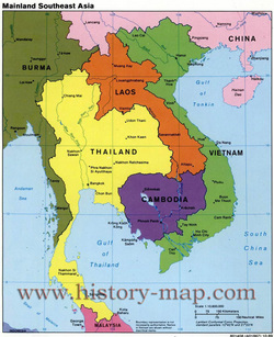
The region of Southeast Asia is made up of the countries of: Philippines, Indonesia, Thailand, Malaysia, Vietnam, Singapore, Cambodia, Laos, Burma, Brunei, Timor-Leste.
Taking a look at some features of Southeast Asia we will see the Mekong River.
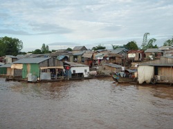
The Mekong River is the longest river in this region and 7th largest river in Asia. It is 2,610 miles long flowing southeast to the South China Sea. The use of food, water and transportation on this river is dependent on by over 60 million people. It is the second largest fishery is located on this river.
An interesting feature to look at is Siargao Island.
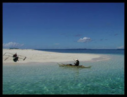
Siargao Island is an island in the Philippine Sea that is shaped like a tear drop and is approximately 437 kilometers. The coast line has reefs, white sandy beaches and small points. The east side of the island is straight with one deep point. The coral and rock reefs make an excellent spot for surfers. The best time of the year for surfing is during the monsoon August through November.
The next interesting feature to learn about is Mount Apo.
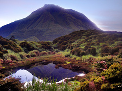
Mount Apo is an active volcano on the island of Mindanao in the Philippines. It is the highest peak at 9,692 feet which is the highest peak in the Philippines. It has a flat top with 3 peaks and over looks Davao City. It is capped by a volcanic crater that has a crater lake. The name Mount Apo means "grand child" (Absolute Astronomy). Because of the the easy to climb summits it is a popular place to climb. No one is sure when it erupted last and there is no known record ever recorded.
Next is Marble Mountain.
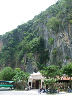
Marble Mountain is a mountain made of five craggy marble outcrops. Each top represents a natural element: Water, Wood, Fire, Metal or Gold and Earth. They have caves built inside them that have tunnels through them. Inside the caves you will find statues of gods, godesses, and buddahs. The military hid in these caves during the American War in 1972. The people living outside the caves made jewelry from the marble of the mountains and sold them until they thought they were running out. There is a stairway leading to the top where you can over look the country side. The monks are the residence that live here now and are the only ones that know their way through the tunnels.
The last feature is the Can Gio Mangrove Forest.
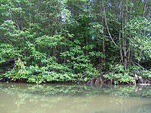
The Can Gio Mangrove Forest is a world biosphere located southeast of Ho Chi Minh City. It was formed by sediment deposits from the Dong Nai and Long Tau Rivers. It has mangroves which contain both salt water and brackish water species. There are more than 200 species of fauna and 52 of flora. Because of the wars, this ecosystem has been devastated. Now it is in the process of being rehabilitated. It is listed in the biosphere reserve by UNESCO.
Climate:
Heavy rainfall from monsoons and inter tropical convergence zone. Wet summers from May til October and dry from November til April. El Nino effects every 2 to 7 years reverses water circulation and air temperature.
Religion:
Islam is the most dominant religion in Indonesia, Malaysia and in the Philippines. Vietnam is a mixture of Buddhist, Confucian, Taoist. Cambodia. Roman Catholic is practiced in Timor-Leste and in the Philippines also. Hinduism is just a small variety in Bali and a few scattered areas.
Population:
There are twice as many people living in Southeast Asia as in the US but is half the size. Around 60% of the population lives on or near the coastlines, rivers and deltas. The remaining 38% of the population live in the city. The family sizes are smaller now and there are declining birth rates. About 30% of the population is of the age of 15 years old and younger. The government has been offering the young incentives to marry and have children to try and up the population. Some of the countries such as Thailand have family planning programs and Buddhism has been accepting the use of contraceptives. Because women are having more opportunities for jobs and education they want to work and higher their education before marriage. HIV-AIDS is a growing health issue with the disease spreading causing more deaths. Aids is the leading cause of death in Thailand between the ages of 20 years old through 40 years.
Agriculture:
Income from agriculture is declining every year. Less than 1/6 of GDP is from agriculture. Rice major export for this region and rubber. Other crops cultivated are sugar, coconut products and palm oil. The crops get rotated every 3 years to help the soil. Some of the cash crops besides rice and rubber are bananas, pineapple and tea.
Environmental Issues:
Logging and farming is causing deforestation. This created non-native species and displacement of plants and animals. Some birds mammals and plants are in extinction. An over abundance of rabbits were eating and destroying the plants and food supply for other species. The grazing animals created an increase in irrigation, herbicides and pesticides polluting under ground water, rivers and lakes. Mining and nuclear weapons during the cold war have destroyed islands, caused cancer, birth defects, miscarriages. They did not remove of the waste products properly and radioactive material infected the land and water. Air pollution from the mines and nuclear plants caused a depletion in the ozone layer. The expansion of hydroelectric plants are also affecting the flow of the rivers which are taking water from others that need it.
References:
International Rivers (no copyright). People-Water-Life: Lancang (Mekong) River. Retrieved from http://www.internationalrivers.org/china/lancang-mekong-river
Lonely Planet (2011). Can Giot: Introducing Can Gio. Retrieved from
http://www.lonelyplanet.com/vietnam/around-ho-chi-minh-city/can-gio
Mount Apo. (2011). Absolute Astronomy. Retrieved from http://www.absoluteastronomy.com/topics/Mount_Apo
Mount Apo. (2011). In Encyclopædia Britannica. Retrieved from
http://www.britannica.com/EBchecked/topic/29712/Mount-Apo
Pulsipher, L. M., and Pulsipher, A. (2008). World Regional Geography: Global Patterns, local lives (4th ed.). New York: W. H. Freeman and Company.
Siargao Island (2006). Hidden Tropical Jewel and the Philippine Surfing Capital. Retrieved from http://www.philippinecountry.com/philippine_beach/siargao.html
Vietnam Spirit Travel (2000-2008). The Spirit of Adventure: Marble Mountain. Retrieved from
http://www.vietnamspirittravel.com/guide/marble_hoian.htm
